Welcome to Past USA. The winter season, which had previously teased the East Coast with mild conditions and sporadic, underwhelming flurries, has violently shifted gears. Currently trending as the number one search across the United States, an impending, historic meteorological event is dominating headlines, social media feeds, and neighborhood conversations.
The National Weather Service (NWS) has sounded the absolute highest alarm for winter precipitation, plunging tens of millions of Americans into a state of high alert. As a monstrous “bomb cyclone” gathers unprecedented strength off the eastern seaboard, an official Blizzard Warning has been issued for the most densely populated corridor in the nation. From the shores of Delaware through the bustling streets of New York City and up into the historic neighborhoods of Boston, residents are bracing for a storm of generational proportions. This is not your average winter weather advisory or a standard snowstorm watch.
The incoming system threatens to unleash a paralyzing combination of blinding, heavy snow, hurricane-force wind gusts, and catastrophic coastal flooding that will fundamentally shut down the I-95 corridor for days. We are tracking up to two feet of snow in some areas, wind gusts exceeding 60 mph, and whiteout conditions that will make travel not just dangerous, but entirely impossible. If you are anywhere in the Northeast, this is the ultimate, real-time guide to understanding the severity of this blockbuster nor’easter, interpreting the meteorological data, preparing your home and family, and navigating the intense aftermath of what meteorologists are already dubbing the defining storm of 2026.
The Scale of the Crisis
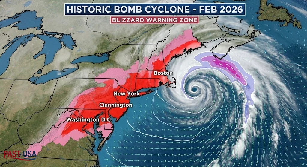
The sheer geographical footprint of this weather system is staggering, encompassing the economic and cultural heart of the United States. When examining the latest forecast models, the scope of this Blizzard Warning covers a massive stretch of the Eastern Seaboard, directly targeting the major metropolitan hubs that house roughly 80 million people. Starting from the Delmarva Peninsula, the intense threat zone moves aggressively northward through the coastal communities of New Jersey, swallowing the entirety of the New York City metropolitan area including Long Island and the lower Hudson Valley.
From there, the bullseye extends through the southern coast of Connecticut, Rhode Island, and encompasses virtually all of eastern Massachusetts, including Boston, the North Shore, and the South Shore. For residents in these areas, the reality is stark: this is a highly volatile, rapidly intensifying situation. Local governments have already begun mobilizing massive fleets of snowplows, salt spreaders, and emergency response vehicles.
However, officials are heavily cautioning the public that human infrastructure will likely be overwhelmed by the sheer rate of snowfall, which is predicted to reach an astonishing one to three inches per hour at the storm’s peak. The density of the population combined with the ferocious nature of the precipitation means that the cascading effects of this event will be felt nationwide, disrupting global supply chains, halting federal operations, and creating a ripple effect of delays and cancellations that will take a full week to untangle.
The Strict Meteorological Criteria
A common misconception among the general public is that the severity of a snowstorm is strictly defined by the total inches of accumulation. In reality, what specifically triggers a Blizzard Warning from the National Weather Service has absolutely nothing to do with the final snow depth, and everything to do with visibility and wind.
To issue this rare and severe bulletin, meteorologists must confidently forecast that three highly specific conditions will occur simultaneously and persist for a minimum of three consecutive hours. First, there must be sustained winds or frequent wind gusts reaching at least 35 miles per hour. Second, there must be falling snow, blowing snow, or a combination of both. Third, this combination of wind and snow must aggressively reduce visibility to one-quarter of a mile or less. There is notably no temperature requirement to meet this definition, though bitter cold often accompanies these systems.
When these three criteria lock into place, the environment transforms into a blinding, disorienting nightmare known as a “whiteout.” During a true whiteout, the horizon completely disappears, distinguishing the sky from the ground becomes impossible, and spatial awareness is instantly lost. This is why emergency management agencies are practically begging residents to stay indoors; even a short walk to a neighbor’s house or a vehicle can result in life-threatening disorientation and extreme exposure to the elements.
The Science Behind the Storm
To understand the ferocity of this late-February tempest, one must dive into the fascinating, albeit terrifying, fluid dynamics of the Earth’s atmosphere. When examining the meteorological mechanics behind the storm triggering this Blizzard Warning, the atmospheric pressure is the true focal point. Forecasters predict that this storm will undergo a rapid intensification process scientifically termed “bombogenesis,” transforming the system into a formidable “bomb cyclone.
” For a storm to be officially classified as a bomb cyclone, its central barometric pressure must plummet by at least 24 millibars within a 24-hour period. This current nor’easter is projected to easily exceed that benchmark. The catalyst for this explosive deepening is a brutal clash of air masses. A plunging, frigid trough of Arctic air sweeping down from the Canadian shield is violently colliding with the relatively warm, moisture-rich air hovering over the Gulf Stream in the Atlantic Ocean.
This extreme temperature gradient acts as high-octane fuel for the low-pressure system. As the warm, moist air rapidly rises, it condenses, releasing immense amounts of latent heat that further accelerate the storm’s rotation and deepen the vacuum at its center. This hyper-accelerated vacuum effect is exactly what generates the destructive, hurricane-force wind gusts that will soon batter the coastline. It is a textbook, perfectly terrifying display of thermodynamic power, engineered by nature to deliver maximum atmospheric violence to the Northeastern coastline.
Breaking the Snow Drought
For many residents of the Northeast, the anxiety surrounding this event is compounded by a noticeable lack of recent, comparable winter experiences. In fact, this particular Blizzard Warning is historic because it forcefully shatters a multi-year “snow drought” that had lulled millions into a false sense of winter security. For the five boroughs of New York City, this is the very first time the highest winter alert has been hoisted by the local forecast office since March of 2017.
Boston, a city legendary for its brutal winters and stoic endurance, has not found itself under this specific severe classification since the historic January 2022 nor’easter. Over the past few years, the region has largely dealt with disappointing, slushy mixes, frustrating rain-snow lines, and storms that ultimately failed to deliver on their catastrophic hype. This prolonged absence of paralyzing snow has created a unique vulnerability; newer residents have never experienced the paralyzing grip of a true whiteout, while seasoned locals may find their emergency preparedness skills rusty.
Historically, storms of this magnitude such as the Great White Hurricane of 1888, the paralyzing Blizzard of 1996, and the record-shattering “Snowzilla” of 2016 leave permanent scars on the cities they strike, reshaping municipal policies, redefining emergency management protocols, and etching themselves forever into the cultural memory of the millions who survived them. This February 2026 event possesses all the atmospheric hallmarks necessary to join the ranks of those legendary, generation-defining tempests.
City-by-City Forecast Breakdown
A storm of this immense size does not distribute its fury evenly; the exact track of the low-pressure center will dictate the ultimate winners and losers in the battle for accumulation. However, the geographic net cast by the Blizzard Warning zone includes nearly every major coastal municipality from New Jersey to the Canadian border. In the New York City metropolitan area, including the heavily populated suburbs of Long Island, northern New Jersey, and Westchester County, current computer models are painting a devastating picture of 12 to 18 inches of heavy, wet snow.
In these areas, the extreme snowfall rates of up to three inches per hour on Sunday evening will simply outpace the mechanical ability of sanitation workers to plow the streets. Further north, the situation becomes even more dire. Boston, along with the North Shore communities and the Merrimack Valley, sits firmly in the jackpot zone. Forecasters are expressing high confidence that these Massachusetts communities will be buried under 18 to 24 inches of powder, with localized pockets potentially seeing incredible totals exceeding two feet.
The timing of the heavy banding beginning Sunday afternoon, intensifying violently overnight, and lingering through the entirety of Monday guarantees that both the Monday morning and evening commutes will be entirely compromised. Even areas slightly inland, like Worcester and the Pioneer Valley, while potentially escaping the most intense wind gusts, are still staring down the barrel of a foot or more of snow, ensuring widespread school closures, business shutdowns, and a complete cessation of normal civic life.
Infrastructure at Risk: Power Outages and Coastal Flooding
While the massive snow totals capture the headlines and the public imagination, emergency planners are intensely focused on a dual threat that is arguably much more dangerous than the precipitation itself. During a Blizzard Warning, power outages become a statistical certainty rather than a mere possibility. The initial phase of this storm will feature temperatures hovering precariously close to the freezing mark. This thermal profile produces “heavy, wet snow” often referred to as heart-attack snow due to the immense physical strain it requires to shovel.
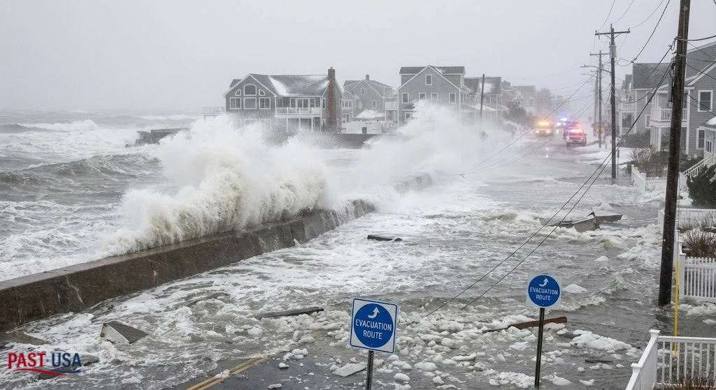
When this dense, concrete-like snow clings to the branches of grand oak and maple trees, and subsequently gets battered by 50 to 60 mph sustained wind gusts, catastrophic failure is inevitable. Limbs will snap, pulling down critical electrical transmission lines and plunging entire neighborhoods into freezing darkness. Compounding the inland electrical crisis is the terrifying threat to the immediate shoreline. A Storm Warning is officially in effect for coastal waters, with breaking surf directly threatening beachfront structures, boardwalks, and seawalls.
The intense, counter-clockwise rotation of the bomb cyclone will aggressively push the Atlantic Ocean into the coastline during multiple high-tide cycles, generating one to two feet of inundation above ground level in vulnerable, low-lying communities. From the barrier islands of the Jersey Shore to the vulnerable harbors of Cape Cod, significant beach erosion, flooded roadways, and damaged coastal properties are expected to exact a heavy financial and emotional toll on coastal residents.
Transportation Paralysis: Trains, Highways, and Aviation
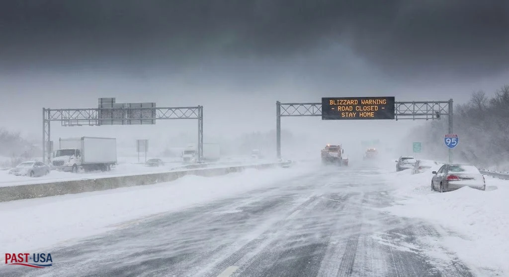
The cascading failure of the region’s transportation network has already begun, transitioning from proactive cancellations to a state of absolute, total paralysis. Navigating a Blizzard Warning travel environment is strongly condemned by all local, state, and federal authorities, with officials pleading for the public to shelter in place. The aviation sector has preemptively capitulated to the storm; thousands of flights originating from or destined for major hubs including John F. Kennedy International, LaGuardia, Newark Liberty, and Boston Logan have been definitively grounded.
The ripple effect of these cancellations has already disrupted the global airspace, leaving thousands of travelers stranded in terminal hotels. On the ground, the situation is equally grim. New Jersey Governor Sherrill has officially declared a State of Emergency, dropping speed limits on critical arteries like the Garden State Parkway and the New Jersey Turnpike. In a drastic, necessary move, NJ Transit has implemented systemwide cross-honoring for all rail, bus, and light rail services, desperate to get residents home safely before the worst of the whiteout conditions materialize.
Highway driving is expected to become a deadly gamble; the combination of zero visibility, rapidly accumulating black ice, and drifting snow means that even heavily outfitted four-wheel-drive vehicles will become helplessly marooned. First responders have explicitly warned that if motorists choose to ignore the travel bans and become stranded, rescue teams will not be able to reach them until the absolute worst of the storm completely subsides.
The Ultimate Emergency Preparedness Guide

As the window for preparation rapidly slams shut, transitioning from proactive planning to immediate survival mode is imperative for everyone in the storm’s path. Surviving a Blizzard Warning requires a meticulous, level-headed approach to self-reliance, as municipal emergency services will be stretched far beyond their operational limits. Your immediate priority must be securing your household and ensuring you have the supplies necessary to weather a multi-day disruption.
- Alternative Heat and Light: Ensure that all portable power banks, laptops, and cellular devices are fully charged immediately. Have flashlights and extra batteries easily accessible in every room.
- Food and Hydration: Stockpile at least three days’ worth of non-perishable food items and one gallon of potable water per person, per day, in the event of widespread, prolonged municipal utility failures.
- Generator Safety: If you are reliant on a portable generator, you must absolutely adhere to the strictest safety protocols; generators must only be operated outdoors, at least twenty feet away from any windows, doors, or vents to prevent fatal carbon monoxide poisoning–a tragic, preventable killer that spikes during severe winter weather events.
- Carbon Monoxide Defense: Check the batteries in all carbon monoxide and smoke detectors to ensure they are fully operational.
- Vehicle Emergency Kits: For those who absolutely must drive in the immediate aftermath of the storm such as essential medical personnel your vehicle must be outfitted with a comprehensive winter survival kit. This should include heavy wool blankets, a dedicated snow shovel, sand or non-clumping kitty litter for tire traction, road flares, jumper cables, and an emergency first-aid kit.
- Pet Safety: Do not forget the most vulnerable members of your household; bring all pets indoors immediately, as the combination of plummeting temperatures and hurricane-force winds will be quickly fatal to animals left exposed to the elements.
Safeguarding Your Property Against the Elements
Beyond personal safety, safeguarding the structural integrity of your property during this extreme weather event requires immediate, preventative action. The sheer weight of 24 inches of wet, heavy snow can pose a severe threat to residential infrastructure, particularly flat roofs, carports, and structurally weakened awnings.
While attempting to clear a roof during the height of the storm is incredibly dangerous and highly discouraged, property owners should be aware of the signs of structural stress, such as new cracks in drywall, sagging ceilings, or doors that suddenly refuse to close properly. Furthermore, the plunging temperatures that will inevitably follow the storm’s departure create a massive risk for frozen and bursting residential water pipes.
To mitigate this expensive disaster, allow a slow, continuous drip of cold water from your faucets, as flowing water is significantly less likely to freeze. Open all under-sink cabinet doors in your kitchen and bathrooms to allow the ambient, warm air of your home to circulate freely around the uninsulated plumbing. If your home loses power and the interior temperature begins to drop dangerously low, wrapping exposed pipes in heavy towels or specialized foam insulation can provide a critical layer of defense.
Lastly, ensure that your home’s exterior exhaust vents particularly those for high-efficiency furnaces and hot water heaters remain entirely clear of drifting snow. A blocked exhaust vent will quickly force deadly, odorless carbon monoxide back into the living spaces of your home, creating a lethal environment in a matter of minutes. Taking these tedious but vital steps now can save thousands of dollars in property damage and prevent catastrophic emergencies.
Conclusion
As the Northeast braces for impact, the collective resilience of millions will be tested by the unrelenting power of this bomb cyclone. The images of empty supermarket shelves, the sound of plows scraping against the asphalt, and the eerie, muffled silence that accompanies heavy snowfall will soon dominate the region.
However, it is crucial to remain calm, stay informed, and respect the sheer destructive capability of Mother Nature. By adhering to the guidance of local officials, staying off the treacherous roadways, and prioritizing the safety of your family and neighbors, the impact of this historic tempest can be safely managed. As the Blizzard Warning expires later this week, the monumental task of digging out and rebuilding will commence, revealing once again the indomitable spirit of the East Coast.
Read about Eric Dane’s Legacy.